Why Streets Meet at Different Angles
Why streets meet at different angles becomes clear when you read the grid, terrain and older routes together, revealing how a junction took shape.
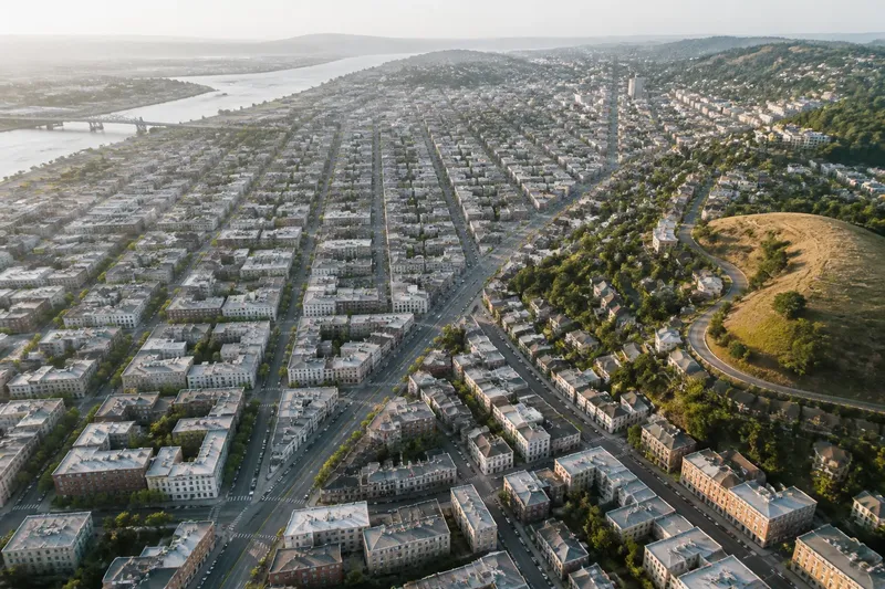
Why streets meet at different angles is often answered by looking beyond the junction itself: a straight grid may have met a slope, an older road or a boundary that ran another way. On a city map, the resulting corner can look untidy, but it often records a practical choice made at a different scale or in a different period. Read the lines around it, and the angle becomes a clue rather than a flaw.
There are three useful ways to interpret an angled junction: as an adjustment to terrain, as a join between distinct street grids, or as a route that predates the surrounding blocks. These explanations can overlap. The aim is not to assign every corner a single origin, but to identify which pattern best explains what you can see.
Start by reading the junction as part of a larger pattern
A junction viewed close up may seem irregular because each street is judged against the other. Pull back on the map and compare several blocks in every direction. Look for parallel streets, repeated block shapes, a line that continues through the junction, and a second cluster of streets that follows another orientation.
A consistent difference between two sets of lines usually matters more than one awkward corner. If several streets turn together, the area may contain two layouts meeting at a seam. If the surrounding streets keep a common direction but bend near a hill or watercourse, terrain may have influenced their alignment. A single diagonal cutting across otherwise regular blocks may be an older route carried forward.
Use a printed street map, an online map with labels and terrain shading, or a city plan if one is available. Keep the map at a scale where you can see blocks as well as neighbourhoods. A close view reveals curb lines and crossing shapes; a broader view shows whether those shapes belong to a larger pattern. Like a seam in a folded sheet, the junction makes more sense when you can see both pieces it connects.
Do not treat a map’s north-up display as an explanation. A grid can be rotated relative to north and still be regular. Compare the streets with one another first, then consider the compass direction and the landscape.
A street grid bends when the ground sets limits
Regular grids make parcels easy to arrange, but they do not always fit slopes, ridges, ravines, shorelines or waterways. A street may follow a contour to avoid a steep climb, while cross streets approach it at different angles. Elsewhere, streets may fan out from a ridge or skirt a low area that would be difficult to cross.
On a map, look for contour lines, shaded relief, stream channels and sudden changes in street direction. A street that curves along the side of a hill may cross a set of straighter blocks. The junctions along its edge can appear oblique because the grid and the contour are serving different purposes. Streets beside a river or harbour may also angle toward the water, then turn to follow the shoreline.
Terrain does not dictate one inevitable layout. A city may cut a street across a slope, route it along the slope, or stop it at a natural obstacle. The choice depends on the route’s role and the land available around it. An angled junction near a steep contour is therefore evidence of adaptation, not proof of a particular engineering decision.
To assess this explanation, compare several nearby junctions rather than relying on one. If the same slant recurs along the edge of a slope, the relationship is more persuasive. If the ground appears level and the street pattern changes abruptly, look next for a boundary or an older route.
Two street grids meet along a neighbourhood seam
Different grids can meet because blocks were laid out separately, at different times, or around different centres. One district may have streets running in one direction, while a neighbouring district uses a rotated grid. At their boundary, streets may end, line up imperfectly or meet at acute and obtuse angles.
The change is often visible across more than one block. Look for a run of junctions with similar misalignment, a boundary street that cuts diagonally across blocks, or a shift in block shapes on either side. A street may also change its name or width at the seam, but a naming change alone does not establish why the layouts differ.
This is a useful explanation when each side looks orderly on its own. The angle is not necessarily a failed attempt to make two streets meet; it may be the visible join between two coherent systems. A boundary can follow a property line, an old edge of development, or a planning decision. A map can show where the patterns diverge, but not always which institution or owner set the line.
When the grid changes gradually, consider whether the map is showing a transition rather than a clean boundary. Streets may be adjusted a little at a time to connect routes, preserve existing parcels or fit a changing landscape. In that case, the seam may spread across several blocks instead of appearing as one sharp dividing line.
Older routes can survive inside newer blocks
Roads and paths often existed before the blocks around them. A route connecting a settlement to a market, bridge, station or crossing may have been widened or absorbed as development spread. If later streets were laid out in a grid, the older line could remain diagonal, producing wedge-shaped parcels and irregular junctions.
Look for a street that continues across several blocks at an angle, especially if smaller streets appear to meet it rather than interrupt it. The line may lead toward a bridge, a former town centre, a station or a gap through difficult ground. On the other hand, a diagonal may have been planned as a modern connector. Its shape alone cannot date it.
Older routes are often easier to recognise through continuity than through appearance. Follow the street beyond the first unusual junction. Does it pass through several different street patterns? Does it connect places that seem to organise the surrounding roads? Does the grid bend around it? Each clue helps distinguish a persistent route from a short diagonal cut between blocks.
Say you are studying a map where a diagonal street crosses two rectangular blocks and reaches a bridge approach. If the same line continues on the far side, while the grid stops and restarts at a different angle, it is reasonable to read the diagonal as a route that the later blocks had to accommodate. That interpretation describes the pattern; it does not establish the route’s exact age or original purpose.
Choose the explanation that fits the map around the corner
Use the question that matches the pattern you see, rather than trying to make every angled junction fit the same story:
- Does the street follow a slope, ridge, stream or shore? A terrain adjustment is the strongest reading when several nearby lines respond to the same landform.
- Do orderly blocks change direction at a boundary? A meeting of separate grids is more likely when the shift repeats along a seam.
- Does one diagonal continue through several blocks or toward a crossing? An inherited route is plausible when the line persists while the surrounding grid appears to accommodate it.
- Do none of these patterns fit? Keep the explanation open. A junction may reflect a parcel edge, a later connection or more than one influence.
Who benefits from each reading? A walker choosing a route may care most about the street’s present direction and crossings, not its origin. Someone comparing neighbourhood layouts may find the grid seam most useful. A reader interested in how a city grew may follow the longest continuous line and then check whether it links recognisable destinations. Each approach answers a different question, so choose according to what you want the map to explain.
For a practical comparison, open the map at two scales. At the closer scale, note which streets actually meet and whether one continues straight through. At the broader scale, trace the street patterns on both sides and check the landform. If the wider view gives a clear pattern, use it as your working explanation; if it does not, describe the junction as a join of uncertain origin instead of forcing a story onto it.
What can an angled junction tell you?
Does a diagonal street always predate the grid?
No. A diagonal can be an older route, a later connector or part of a planned layout. Continuity across blocks and the way surrounding streets respond offer clues, but the angle alone cannot establish when it appeared.
Why do streets meet at different angles near a hill?
One street may follow a contour while another crosses the slope, or the layout may change to avoid steep ground. Compare the junction with terrain shading and nearby streets before deciding that the hill explains it.
Can two regular grids meet without a straight boundary?
Yes. Their directions can shift gradually, leaving several imperfect joins rather than one dividing line. Look for a broader change in block shape and orientation, not only a single boundary street.
What if the map shows no obvious cause?
Record what is visible: the street directions, the blocks that continue, and any change in terrain or route. If no pattern supports a stronger claim, uncertainty is more useful than an invented origin.
Separate visible evidence from a confident origin story
A street map can show alignment, continuity, block shape and connections. Terrain layers can suggest why a line turns or stops. These are good grounds for describing a pattern, but they do not reveal every property decision or planning change behind it. When the origin matters, consult a local plan, map collection or municipal history rather than treating a present-day map as a complete record.
Keep your notes precise: “the grid rotates beyond this junction” is observable; “the street was built to reach a former market” needs evidence beyond its direction. That distinction makes a map reading useful without making it sound more certain than it is.
Why streets meet at different angles becomes easier to answer once you compare the ground, the grid and the line that continues through the blocks. Start with the pattern you can see, then choose the explanation that fits the widest area. When the evidence remains mixed, leave the corner unresolved; the gap in your explanation is also a truthful part of reading the city.